Please Note:
The development of the CHERP Mobile App is currently on hold as we shift our focus to CanVI: The Canadian Assessment of Community Hazard and Climate Vulnerability and our other related projects.
CHERP requires significant funding and community support to operate in its current form, and this is not something we can maintain as a side project at the current time. We have plans for a complete top-to-bottom rewrite of the application once a clear source for funding and a mechanism to support community integration better can be identified. Those seeking to explore supporting the redevelopment of CHERP are encouraged to contact us at info@resiliencemapping.ca.

“What would happen if we helped to make it quicker and easier for community residents to learn about, prepare for and respond to local hazard threats?”
– Dr. Ryan Reynolds
What is CHERP?
About the Canadian Hazards Emergency Response & Preparedness Initiative
CHERP is a research outreach and engagement project with the goal of making it quicker and easier for community residents to learn about, prepare for, and respond to local environmental and climate-related hazard threats.
Our research team conducted workshops with potential partner communities during the initial pilot stage to better understand the hazard risk assessment information they had to share with residents and how best to share it. We used this information to develop and refine a mobile app that dramatically simplifies household emergency planning and adapts to unique community and household conditions.
Our approach combines extensive on-the-ground knowledge from our community partners with our research team’s knowledge of hazard risk and risk communications to build something local in focus yet informed by national and international best practices.
The CHERP Mobile App
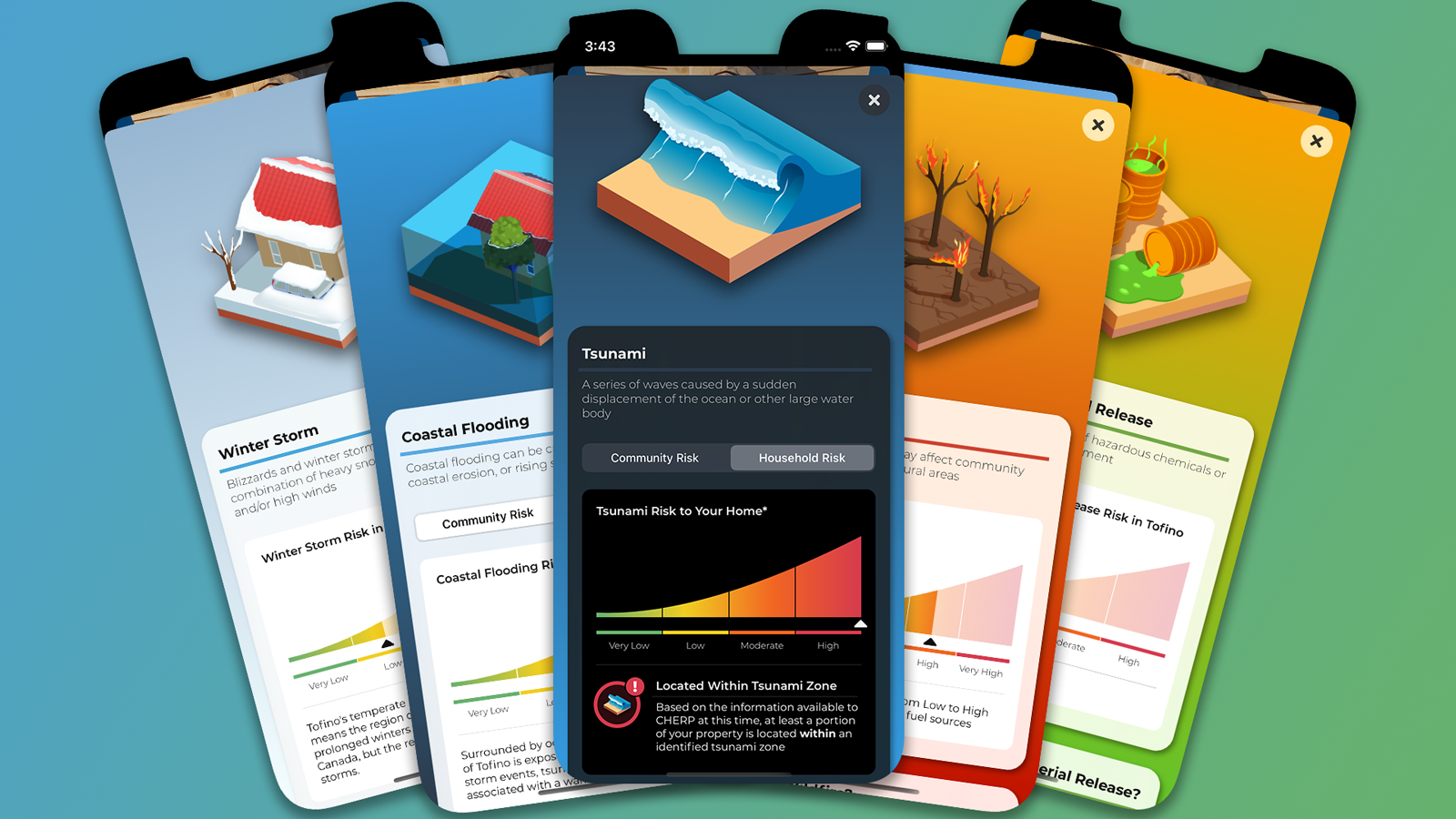
The CHERP mobile app’s five main sections (v0.9 shown from iPhone 14 Pro)
The CHERP mobile app is the first product from the CHERP research initiative. The app helps educate residents of our partner communities about local hazards, assists with emergency planning, and provides the tools and information residents will need in an emergency.
The mobile app combines information from official community planning documents, hazard risk assessments, and information users provide about their homes and households to identify their hazard exposure and generate personalized emergency preparedness and response plans.
Users can use the mobile app to:
Learn which hazards are most likely to impact their community
Determine if their home is located in any identified hazard zones*
Find out how to receive official warnings and notifications from their communities*
Find out where to look or listen for up-to-the-moment information from community officials in an emergency
Locate safe evacuation destinations and the services available at these locations*
Discover what actions they can take in advance to reduce potential impacts to their home and family
Generate custom emergency plans based on their home’s location and the needs of household members and pets
Each section of the app is discussed in greater detail below.
* Not all elements are available in all CHERP partner communities. Items marked with an asterisk are only presented if relevant data is available and shared with us by our community partners.
Household Information Tab
The Household Information Tab collects information your home and family to help develop personalized emergency response plans (v0.9 shown from iPhone 14 Pro)
The Household Tab is where CHERP collects information about your home, family, pets, and vehicles. The app uses this information to adapt the planning and emergency response information it provides to best match these actions to the unique needs of your household.
It should come as no surprise that the emergency planning and response needs of a young family of six living in a detached home will vary from those of a single retiree with mobility issues living in a third-storey apartment. Most emergency planning checklists provided by governments and NGOs fail to take this reality into account, instead providing overly-general information or spreading their guidance across multiple checklists. CHERP simplifies the planning process by comparing your household’s needs to identify those actions best suited to your family’s situation, whatever that might look like.
The app also uses your home’s location to provide you with a clearer picture of which hazards are most likely to affect your home, based on hazard risk information provided by our community partners. Using the best information available to us, we can provide quick assessments of your home’s hazard exposure for hazards like tsunami, flooding, and landslides where risks can be modelled in advance. This helps reduce any uncertainty and make sure you know exactly which hazards are most critical for planning purposes.
Community Profile Tab
The Community Profile Tab provides information about local hazards along with local preparedness and response information (v0.9 shown from iPhone 14 Pro)
The Community Profile Tab focuses on local hazard risk conditions along with preparedness and response information relevant at the community scale. This tab allows users to dive into details about local hazards, provides links about where find critical information, and helps residents learn where to go if they need to leave their homes in an emergency.
This component of the CHERP app brings together the various hazard information for your community from local, regional, provincial, and federal sources so everything you need is quickly at hand when you need it. From learning about the top hazards in your community, to mapping out your nearest refuge area, CHERP can help educate and prepare you for local hazard risks.
And when an emergency does occur, this tab provides you with quick and easy access to information about local warning and notification systems and where to look for up-to-the-moment instructions from local and provincial officials. No more hunting for website URLs or social media links: just scroll down and tap to brought right to your community or regional district’s official channels.
Project Goals
CHERP was initially envisioned with four primary goals for our community partnerships:
To better understand hazard preparedness within our partner communities.
To help increase household hazard resilience in Canada, especially for coastal hazards.
To build and strengthen the ties linking academic researchers, community practitioners, and residents around hazard risk communication.
To develop a shared set of planning actions, language, and best practices for household hazard risk communication related to household preparedness and response.
These initial goals were refined through a pair of workshops with our community partners and guests. Our final mission was to come together to help Canadian households to improve their understanding of local hazard risks, develop appropriate emergency plans, and be ready to respond in the event of a hazards-related emergency. This led to the development and refinement of the CHERP mobile app, discussed in more depth in the following sections.
My Involvement with CHERP
The idea behind CHERP comes from work I completed during my doctoral studies into tsunami risk and household preparedness. I am both the lead researcher and application developer for the project, working in collaboration with emergency managers from the initial seven communities who have signed onto the project.
My responsibilities on the project are summarized below:
Project Management
Acquisition of initial funding for Phase I of the project through MEOPAR’s Knowledge Mobilization and UBC’s Community-University Engagement Support funds
Conducting workshops and one-on-one sessions with or community partners, including all research ethics applications
Meetings with individual community liaisons
Financial reporting to UBC and our funding agencies
Supervision of project’s research assistant
Continued improvements and funding acquisition for Phase II of the project
GeoSpatial Risk Assessment
Collection and integration of community hazard data, where available
Household-level risk assessments using ESRI’s ArcGIS Pro suite and custom ArcPy code (Python)
Exporting community household risk assessments to GeoJSON files for integration into the CHERP mobile app
Application Design and Development
iOS application in XCode using Swift and SwiftUI
Staging, deployment, and management of test builds to internal and external testing groups
Integration of bug fixes and feature enhancements informed by user and partner community feedback
Related Webinars:
Communicating Local Climate & Hazard Risk Information to At-Risk Community Residents
March 2, 2022
Host: MEOPAR Coast and Ocean Risk Communication Community of Practice
Ryan will spoke about community resilience, household preparendess, some of the reasons we don’t prepare for emergencies, and the CHERP mobile app through the lens of risk communication.
The CHERP Research Project: 2022 Update
February 1, 2022
Host: MEOPAR Annual Science Meeting
This presentation provides an update on the work that has been underway as part of the CHERP mobile app throughout 2021 as we prepare the app for it’s first public roll-out in our partner communities.
The CHERP Mobile App
January 22, 2022
Host: EMBC/JIBC Emergency Management Webinar
Ryan and Alexa Tanner presented information about community resilience, household preparedness, behavioural biases, and how these come together in the CHERP mobile app.

